First printed in the Aug 2019 Cottage Grove Historical Society Newsletter
The earliest white settlers to build homes in the Cottage Grove area begin arriving in 1847 with Richard Robinson building on a tract of land just to our north in what is now the Walker area and James Chapin building a home in what is now Latham. Over the following few years new settlers would move into the area creating the foundation for our town. In those early years four settlers staked claims that would become the core of our community, Cottage Grove. Four names will forever be a part of our history: Cochran, Shields, Small, and McFarland.
Cochran
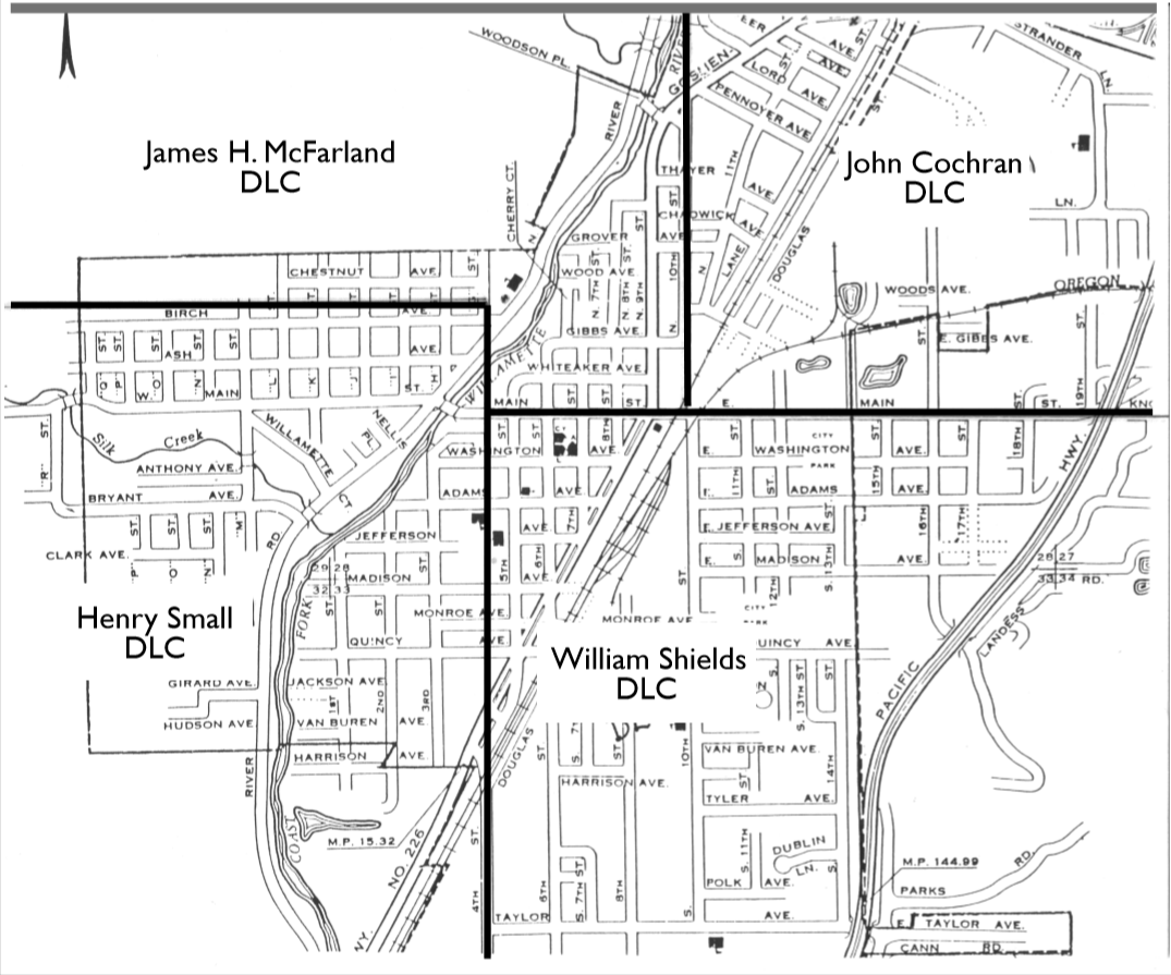
John and Letticia Cochran’s Donation Land Claim (DLC) makes up the northeast quadrant of town. From Main Street North and 10th street east. John was born in Illinois in 1817 and Letticia was born about 1820, also in Illinois. They married in Oct of 1838. According to family records the Cochran’s moved to the area in 1847. Other sources state different years including 1849 and 1850. With the Donation Land Claim act going into effect in 1850 this is the year they filed their claim. Their DLC, #1153, was 643 acres and was settled in 1852.
John and Letticia traveled to Oregon with livestock and the hopes of selling meat to miners in the gold fields. John regularly traveled to Northern California to sell meat. It was reported that John died shortly after returning from one of these trips in July of 1859. No cause of death was listed. Letticia later married Samuel Dillard who had a DLC near Saginaw.
| Donation Land Act of 1850 |
|
Timeline of Oregon Land DistributionDistribution Congress passed the Oregon Donation Land Law in 1850, giving 320 acres to all white or half Indian male citizens (with white fathers) and an additional 320 acres to their wives. This legitimized a 1843 offer made under the provisional territorial government. Claims made between 1843 and 1850 were eligible for the full 640 acres, if married. Citizens arriving after Dec 1, 1850 were eligible for 1/2 that amount or a maximum of 320 acres. It is noteworthy that this law required the 320 additional acres for married couples be placed in the wife’s name making it one of the first times women in the United States could hold legal rights to land. |
Though it was built 40 years after John’s death the barn, originally known as the John Cochran barn, was built near the center of what was his DLC. Later made famous by the advertisement painted on the side for Dr. Pierce’s Pleasant Pellets, this barn was a long time local landmark loved by many
as the Dr. Pierce Barn. Unfortunate this was torn down a few years ago.
Shields
William and Judith (identified as Judah in some sources) Shields’s DLC covers the south east portion of town from main street south and about 4th street east. William was born in 1799 in Tennessee and Judith was born in 1810 Kentucky. They were married in Dec of 1830 and settled in Oregon in Aug 1851. It was stated in one source that John Cochran wanted neighbors so badly that when the Shields showed up in the area John convinced them to stay, offering them his claim and claiming the tract of land just to the north. While this may be true, it seems interesting that the Cochran’s ended up with much better river access on their new tract of land. The Shields settled their DLC, #340, in Sept 1852. Their claim was 319.85 acres. William and Judith would go on to acquire over 900 acres of land in and around Cottage Grove. The family donated the land for Shields Cemetery.
Small
Henry and Nancy Small’s DLC runs from about Birch Avenue south and 4th street west making up the south west quadrant of town. This is also the original location of Downtown Cottage Grove, known as Slabtown during the feud years and making up south River Road today. Henry was born in 1812 in Tennessee, no birth date was found for Nancy. They married in April of 1836 in Missouri and arrived in Oregon in October of 1850. They would spend a couple years in the Brownsville area before moving to this area in 1852, Their claim, #483, was settled in April of 1853 and consisted of 642.42 acres.
In 1852 the Smalls donated land for the first school house in the area. It would become known as Latham and was originally located near what is now Sweet Lane and 99S.
Jeremiah Yarnell and O.P. Adams bought the Smalls claim in 1859. The Smalls moved to California, while Yarnell and Adams proceeded to section out the land selling several parcels. The division of the land claim would form the initial layout of the town of Cottage Grove. The first plat of Cottage Grove developed out of this land claim, was filed in 1869. It was also on the Small’s land that the first Main Street in Cottage Grove would spring up. Running through their claim was the ancient trail used by Indians, fur trappers, early Applegate Trail travelers, then as a stagecoach routes, early highway, Main Street and now South River Road.
McFarland
James and Mary McFarland’s DLC includes the north west portion of town. From 10th Street west and Birch Ave North. One portion from 10th to around 4th street their DLC dips down to Main Street. James was born in 1807 in North Carolina and Mary, aka Polly, was born in 1811 in Kentucky. Their married in 1832 and arrived in Oregon in Oct of 1853. They settled their Claim, #345, in Oct 1853. Their original claim included 639.33 acres.
James and his brother John had originally traveled to the area in 1850 to scope out the potentials of the area. They clearly liked what they saw as they went back east and brought their families west. According to Golden Was the Past, the McFarlands choose tracts of land on higher ground because they had dealt with frequent floods when they lived on the Missouri River.
| A Names Journey |
| The name Cottage Grove came from a post office established in 1854 just east of Creswell. Over the years it moved a few times, roughly following what is now Hwy 99 heading south until it reached this area in 1867. The 1870 census lists the Cottage Grove post office as located in the Coast Fork Township. In 1887 the community incorporated as a city under the name Cottage Grove. |
There is much more to explore to get to know the early families that staked claims that grew into our town, but that will need to be saved for another time. The brief introductions provided here should serve as a reminder that the place we call home, that has recently topped 10,000 in population, had beginnings sprung from the hopes and dreams of settlers coming west and laying claim to unfamiliar land far from home. If you live in town, you now know on whose DLC you reside. If you live outside of the area discussed here, then you can find additional DLC land maps at our Research Library or at the Genealogical Society Library.
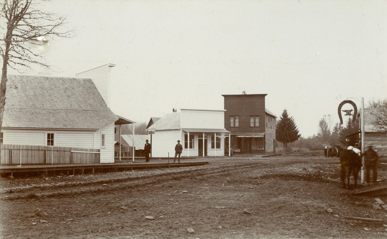
Picture: Early Commercial District, picture is labeled 1870. Located on the original DLC of Henry Small, this is the intersection of Main and River Rd. Today you would see the Masonic hall in the center, Riverview Terrace to the left, and the Applegate trail interpretive center/Centennial bridge on the far right.